Hurricane Erin 2025: Massive Storm Poses Life-Threatening Rip Current Risk to US East Coast
The Atlantic’s first hurricane of the 2025 season, Hurricane Erin 2025, has evolved into a formidable Category 4 storm. While it’s forecast to remain well offshore, its immense size is a major concern, as it threatens to bring life-threatening rip currents and towering waves to the U.S. East Coast and Bermuda starting this week.
The storm’s broad footprint is already sending large swells across the ocean, creating perilous conditions that have prompted officials to urge beachgoers to stay out of the water. With peak summer crowds still at the coast, the risk is especially high.
Life-Threatening Impacts from a Safe Distance
Although Hurricane Erin 2025 is not expected to make a direct U.S. landfall, its influence will be felt acutely along the shoreline. The storm’s sheer size will generate dangerous surf, powerful currents, and coastal flooding during high tides.
The most immediate danger is along the Outer Banks of North Carolina, where Dare County has already issued a local state of emergency and a mandatory evacuation for Hatteras Island. Portions of N.C. Highway 12 are expected to be impassable for several days due to coastal flooding.
Further north, from South Carolina to the Delmarva Peninsula and New Jersey shore, the risk for rip currents is expected to climb sharply from Tuesday through Thursday, even under otherwise sunny skies. Bermuda is also in the storm’s path of influence and is expected to experience very rough seas and possibly tropical storm-force winds.
Understanding and Surviving Rip Currents
Rip currents have proven to be one of the top weather-related killers in the U.S., claiming more lives each year than lightning, hurricanes, and tornadoes combined. Despite the alarming statistics, many people don’t know how to recognize or escape them.
A rip current is a powerful, narrow channel of water flowing rapidly away from the shore. They are often difficult to spot, but signs can include a break in the incoming wave pattern, a channel of churning, choppy water, or a line of foam or seaweed moving steadily seaward.
If you get caught in a rip current, remember to stay calm and don’t fight it. Swimming directly against the current will only exhaust you. Instead, follow these steps:
- Swim Parallel to the Shore: Since rip currents are typically narrow, swimming parallel to the beach will allow you to escape the current’s pull.
- Float: If you are unable to swim out of the current, conserve your energy by floating on your back until the current dissipates. Rip currents don’t last forever and will often carry you to an area where you can safely swim back to shore.
- Yell for Help: Once you are out of the current, or if you can’t escape it, wave your arms and yell to signal for help.
The Science Behind Erin’s Historic Intensification
Hurricane Erin 2025 made history over the weekend with one of the fastest intensification bursts on record. In just over a day, it transformed from a tropical storm into a ferocious Category 5 hurricane. This rapid strengthening was fueled by exceptionally warm ocean water and ideal atmospheric conditions.
The storm later weakened to a Category 3 during a process called an eyewall replacement cycle. This is a natural phenomenon in intense hurricanes where a new, larger eyewall forms around the old one, temporarily disrupting the storm’s structure and causing its winds to drop. After the cycle was complete, Erin re-intensified to a Category 4, with an even broader wind field that expanded its zone of dangerous surf and rip currents.
Erin’s Impact on the Islands
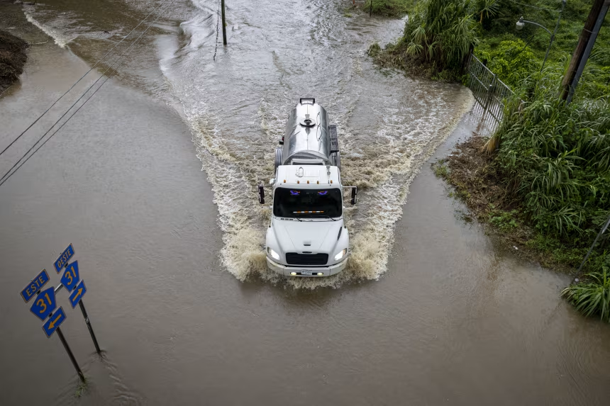
Before turning north, Erin’s outer rain bands lashed the Caribbean. Puerto Rico saw heavy rainfall, which triggered flash flooding and power outages for over 100,000 residents. Tropical storm warnings remain in effect for the Turks and Caicos Islands and the southeastern Bahamas, with up to 6 inches of additional rain forecast, raising the risk of landslides and mudslides.
As Erin moves away, the Atlantic hurricane season is just beginning to ramp up. Forecasters expect above-average tropical activity, and with record-warm ocean temperatures still present, Hurricane Erin 2025 may be just the first of several major storms to watch this year.